Directions/Parking
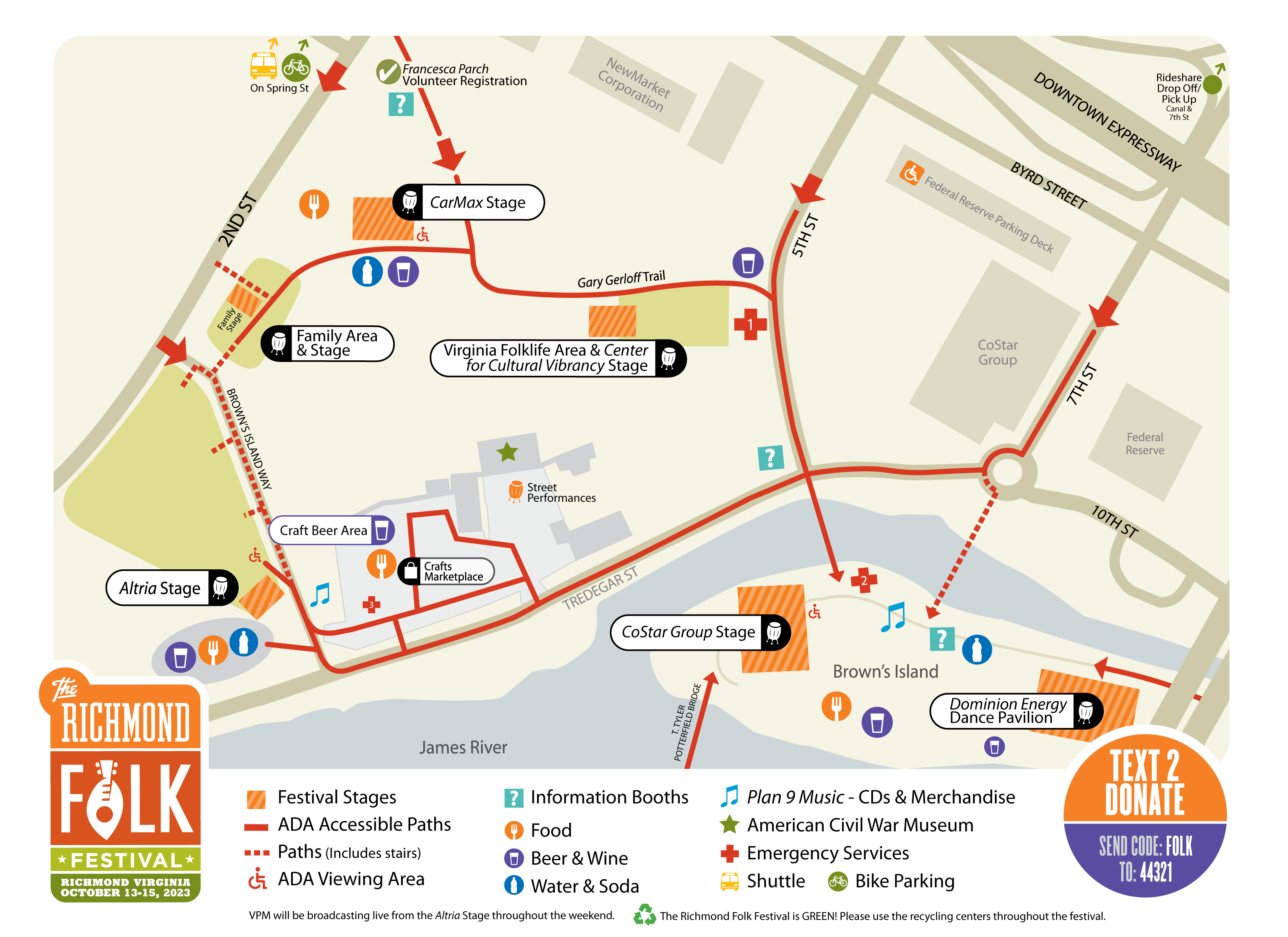
The Richmond Folk Festival takes place on downtown Richmond's historic riverfront, from 2nd to 7th streets and from Byrd Street to the river – including Brown's Island, the American Civil War Museum at Tredegar, portions of Federal Reserve parking lots, and Tredegar Street.
For guest safety, vehicular traffic is not permitted on the actual event site. All streets leading into the site are closed to vehicular traffic at Canal Street (two blocks north of the site).
Traveling from outside of the Richmond area? Come by train!
Amtrak is the official travel partner of The Richmond Folk Festival and is a great way to attend! Book now to take advantage of specials!
ADMISSION - FREE
The Richmond Folk Festival is a FREE event – you can enjoy the performances, the Virginia Folk Life Area & Stage, and the Family Area at no cost. Food, drink, and merchandise are available for sale.
GRTC BUS TRANSPORTATION
GRTC offers FREE and easy options for Downtown’s riverfront. Take any of these bus routes (#3A, 3B, 3C, or #87) to the stop at Belvidere and Holly (southbound) or Belvidere and War Memorial (northbound) by the river. The #3A/B/C routes operate every 30 minutes, and the #87 bus runs every 60 minutes. Just look for the GRTC signs! If you need help planning your bus trip, use Google Trip Planner or call GRTC 804-358-4782. GRTC is currently FREE to ride.
RIDE-SHARE DROP-OFF AND PICK-UP
The easiest place to be dropped off for the festival is conveniently located at 690 BYRD STREET.
Satellite parking and shuttle
Off-site parking is available at Dogwood Dell SATURDAY AND SUNDAY only.
Bus will take you to Spring St within the festival site.
Buses run ROUGHLY every 30 minutes.
Saturday, Oct 14 – 11:45 am–10:00 pm
Sunday, Oct 15– 11:45 am–7:00 pm
$5 per adult roundtrip. Debit/Credit Only.
The Dogwood Dell parking area entrance is located off of Park Drive in Richmond, VA 23220.
Downtown Festival PARKING
Multiple parking lots are available downtown and in Manchester.
5th & Canal Street: public parking after 5:00 pm on weekdays, and 24/7 on weekends (Rates: $6.50 for 8 hrs; pay through “ParkMobile” by app or QR code, see signage on-site)
4th & Canal Street: public parking 24/7 (Weekday Rates: $4.50 for 1 hr; $9.00 for 2 hrs; $13.50 for 3 hrs; Evening Rate: $6.50 for 8 hrs; pay through “ParkMobile” by app or QR code, see signage on-site)
1200 E Byrd Street (Reynolds lot): public parking 24/7 (Rates: see signage and pay-to-park kiosk on-site)
8th & Cary Parking Deck (Rates: see signage and pay-to-park kiosk on-site)
13 North 5th St., Second Presbyterian Church Garage: public paid parking (Rates: see signage and pay-to-park kiosk on-site)
900 East Cary St., Mutual Parking Garage: public paid parking (Rates: see signage and pay-to-park kiosk on-site)
901 Semmes Ave., CoStar Group parking lot in Manchester: FREE for Folk Festival parking ONLY.
October 13: 5:30 pm -11 pm
October 14: 10 am -10:30 pm
October 15: 10 am – 7 pm
For street parking, download the Passport App to make it easy!
SITE ACCESSIBILITY AND HANDICAP PARKING
Handicap parking is available in the Federal Reserve Parking Deck located on the corner of 5th and Byrd Streets. A traffic control officer will be at the intersection to allow properly identified vehicles through.
During the festival, an ADA shuttle will run from the Federal Reserve Parking deck to 5th and Tredegar St.
There will not be onsite transportation available between the various stages, but three stages, the CoStar Group Stage, Dominion Energy Dance Pavilion and the Altria Stage are wheelchair accessible, from which you can see all of the performers through the course of the festival. See our site map for more info on these locations.
Canal Walk Construction
For the remainder of 2024, Canal Walk access to Brown’s Island from the east will be diverted to Tredegar Street via Haxall Point and 10th Street. Pedestrians will still be able to access the east side of the island using the the pedestrian Bridge located underneath the Manchester bridge off of Tredegar Street. Those with bikes or wheeled mobility devices will most easily access the island via the 5th St. pedestrian bridge. Brown’s Island will still be accessible from all other direction as normal, utilizing the the 5th and 7th Street pedestrian bridges, the vehicular bridge across from the Civil War Museum, and the “TPott” bridge from the south side of the river.
For a description of the project and a detailed map of the detours please visit the Dominion Energy website.